


Bathymetric surveys of farm dams and storages
We survey the bed of your dam or storage from the water, with no need to drain it, so you know how much it really holds and where the silt is.
Overview
Bathymetry, in plain words.
Bathymetry is measuring how deep the water is and mapping the shape of the ground beneath it. It is often called underwater topography: a contour map of the bed of a dam, channel or river. On a farm, it tells you how much water a storage really holds.
Farm managers
Know the real volume in storage, and how much of it you can actually pump.
Buyers and investors
Check that a property's storages hold what the plans say.
Designers and engineers
Measured levels and volumes for storage upgrades, pump suctions and water budgets.
What we do
What we cover.
The survey boat
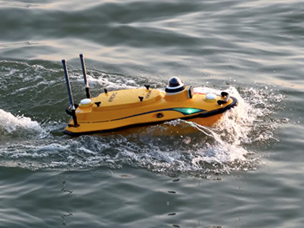
An uncrewed survey boat runs lines across the water, measuring depth with sonar while RTK GPS fixes its position. Every reading becomes a point on the bed with a true level, and the points build a 3D surface of the storage.
- No one has to go in the water
- No need to drain or empty the storage
- Depth and position recorded together
- Dams, storages, channels, rivers and lagoons
Real storage capacity
The capacity on the plan may never have been checked, and it drops as silt settles. The survey measures what the storage holds now, and gives a capacity table of volume at each water level.
- Volume at full supply level
- Capacity table by water level
- Dead storage below the lowest outlet or suction
- Comparison with the design figure
Silt build up
Silt takes up space that should hold water, and can build up around intakes. Compared with the design levels or an earlier survey, the bed map shows how much silt has settled, and where.
- Where silt has built up
- Volume lost since the design or last survey
- Areas to target for desilting
- A baseline for future surveys
Depth at intakes and pump suctions
A pump needs enough water over its suction to run properly. We map the depth at intakes and pump sites in dams, channels, rivers and lagoons, so you can see how much water sits above each suction as levels drop.
- Depth at each intake and pump suction
- River, lagoon and channel pump sites
- Changes in the bed near the intake
- Input to suction and pump station design
Water budgets and storage upgrades
Measured volumes go into the water budget for the property, and into the design when a storage is enlarged, desilted or rebuilt. Our engineers design from the same survey, with no handover to another firm.
- Storage volumes for the water budget
- Levels for enlarging or reshaping a storage
- Cut and fill for desilting works
- Storage checks for due diligence
What you get
Measured volumes and depths, not estimates.
- 3D surface and contour map of the bed
- Storage capacity at full supply level
- Capacity table of volume by water level
- Dead storage volume
- Silt build up against the design or last survey
- Depth at intakes and pump suctions
- CAD files for design and earthworks
- A plain report on what the survey found
Questions
Bathymetry, answered.
What is a bathymetry survey?
A bathymetry survey measures the depth of water and maps the shape of the ground beneath it. The result is like a contour survey of the bed. On a farm, it is used on dams, storages, channels and river pump sites to find out how much water a storage holds, how much silt has built up and how deep the water is at the intake.
How do you calculate dam capacity?
Capacity is the volume between the bed of the dam and the water surface at full supply level. The rough way is to measure the surface area and depth and apply a shape factor: a common rule of thumb for a gully dam is surface area times maximum depth times 0.4. That assumes an even shape, and real dams have uneven beds, silt and banks that have slumped, so the estimate can differ a lot from the real volume. A bathymetric survey measures the bed itself, and the volume is calculated from the 3D surface at every water level.
Can you use LiDAR for bathymetry?
Not on most farm water. Standard LiDAR from a drone or aircraft doesn't see through water, and bathymetric LiDAR only works in clear water, which farm dams, channels and rivers rarely are. Sonar from a boat measures depth whatever the water clarity, which is why we use the survey boat. The banks above the water line can be picked up with a drone or RTK GPS.
How much does a bathymetric survey cost?
It's priced on application, because every storage is different. What drives the price: the size and number of dams or storages, access and where the boat can be launched, whether the banks above the water line need surveying too, the outputs you need (capacity table, silt comparison, report), and travel. Send the property location and the storages you want surveyed, and we'll come back with a scope and a price.
Is a hydrographic survey the same as a bathymetric survey?
For a farm dam, channel or river pump site, they mean the same job. Hydrographic survey is the broader term, used for ports and coasts, and can cover tides, currents and the shoreline as well as depth. Bathymetric survey is the depth and bed mapping part, which is what a farm storage needs.
What is dead storage in a dam?
Dead storage is the water below your lowest outlet or pump suction, which you can't draw on. It still counts in the total capacity, so the usable volume is less than the figure on the plan. The survey maps the bed around outlets and suctions, so dead storage can be calculated and the usable volume shown separately.
Related
How much water is really in your dam?
Send the property location, the storages you want surveyed and what you need the figures for. Nick, Matt or Aaron will call you back with a scope and a price.